Day 2: Arnarstapi to Pingvellir
 We woke up quite early on the 2nd day. Two cans of beer made of Icelandic water did not have any effect. Yes, there was a different need to - there were only two toilets in the hotel for I dont know how many people and we wanted to finish our duties before people started to queue up. The plan for the day was to have a walk around Arnarstapi on the cliff edge and then drive towards Pingvellir and Geysir to take the famous Golden Triangle route. We were ready by 0800 hrs just in time to enter the restaurant for the buffet breakfast.
  On every trip, I have always liked the continental buffet breakfast where one can have many different options to choose from. The sun was shining brightly and it was the most ideal condition to walk around the sea cliffs. When we came out of the restaurant, it was sad to see that our vehicle looked really old and worn out amongst all other vehicles in the car park. Of course, everything comes at a price and we had opted for the cheaper alternatives.
 A short walk along the only road led us to the harbor at the end of the village. Arnarstapi is known as a small fishing village and history mentions this place as an important trading center in the past. Till date, this is the best picturesque location I have ever visited amongst all my trips. The beautiful blue sea, the never ending coastline of cliffs and Mt. Snaefellsjokull towering at distance made the perfect setting for a song sequence in a Bollywood movie. Such locations in the movies always creates that dreamy desire amongst the viewers to go there someday and there I was in one such place. From the harbor area, we also took the picture famous (the one which is mostly seen on the websites if you hunt for this place) - the lone house with the Snaefellsjokull in the background and the edge of the cliff.
 There is a well-marked route from Arnarstapi to Hellnar along the coast and a walk on this route revealed the magnificent lava formations on the coastline. The lava formations were in myriads of different shapes and it looked like they have been chiseled away by expert sculptors very delicately in their spare time. The lava formations have been attributed to volcanic activity on Mt. Snaeffelsjokull several hundred years ago. Some of the rock formations are structures coming out of the sea whereas many others were in the shapes of blowholes of different sizes.

 Nature probably had its share of fun when it forced the sea to do the hard work of shaping the rocks. I liked one specific lava formation. Two of us were standing on the edge of a cliff and admiring the sea in the front and our third friend was taking pictures of a big gorge right behind us. He called us from behind and told that we were actually standing on top of a small strip of land and the bottom was totally hollow with the sea below. We hurried down to the place where he was standing.
 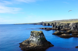 It was a beautiful hollow formation on the edge of the cliff and the gorge which my friend was taking picture of, directly leads through it into the sea. It would have been real fun to go down to the sea through this gorge, but that was really risky without the right equipment. The rugged cliffs are also home to hundreds of Arctic terns (http://en.wikipedia.org/wiki/Arctic_Tern) and so the sides of the cliffs were all white and you know it quite well why is that. So, when you walk along the cliff, there is a characteristics smell of the tern faeces and there will be a continuous noise of their chatter.
 Inside the gorge, we could see several tern chicks trying to grab their parent's attention and also food through continuous singing.Once in a while, a group of terns would just fly out into the air which makes a fabulous sight. The walk led us to the same place near the monument where we went the previous evening.
 It was time now for us to move on to our next destination - Geysir. On our way to Arnarstapi yesterday, we had seen the diversion to go towards Olafsvik, another town which we have to pass to reach Geysir. The interesting part is that we are going to go closer to the Snaeffelsjokull glacier along the way. We bade goodbye to Arnarstapi and hit the main road towards Olafsvik. We were not taking the regular route but the one which passes close to the glacier. A few kilometres of drive brought us to the junction where we have to take the diversion. Now, this is not a tar road, but a gravel road. Again, the fears of our aging vehicle started to bother us, but we had no choice, right.

 We were driving up and through the mountain ranges with vast open green fields to give us company. The weather had become dull and cloudy. The green fields slowly changed to black lava fields as we climbed up further. The volcanic activity from Snaeffelsjokull had altered the landscape around the entire Snaeffelsjokull peninsula and we have already seen that the effects extend to the sea in many areas.
  Soon, we reached the topmost portion of the Snaeffelsjokull region from where if you wish, you can climb up to the top of the Snaeffelsjokull glacier. The glacier portion of the mountain was the only region where we could see snow, else all other mountains were bare. The awesome views of the landscape - the peninsula and the sea from this point was a treat for the eyes. History mentions that the volcano below the glacier erupted around 2000 years back and since then, the volcano has been dormant.
  I read that it is quite easy to climb to the top of the glacier, but we did not have time in our hands. There, it seems is a volcanic crater at the top of the mountain which is around 200 m deep and almost all the time, the crater is filled with ice. Now, I am sure all of you will remember that Snaeffelsjokull glacier became famous due to its reference in the Jules Verne novel "Journey to the Center of the Earth" (http://en.wikipedia.org/wiki/A_Journey_to_the_Center_of_the_Earth). As you read in the novel, this is the mountain through which you can reach the centre of the earth. We continued on our drive downhill now and it was a nice roller-coaster ride through numerous ups and downs. Going round and round through the mountain ranges, we could not stop admiring the surroundings.
  Occasionally, the lava fields were replaced with lot of greenery and beautiful water streams. One thing for sure is that there will be no dearth of water in Iceland. Soon, we hit the main road and it was time for a much needed break, guess for what, LUNCH. There was a beautiful village with a restaurant along the way and we had our next round of quick stuff-burgers. I am amazed - I always get a vegetarian option at these places too.

 The next portion of the drive also had a long stretch of gravel road. Now, suddenly, we are seeing more water-bodies amongst the vast lava fields. The area surrounding the small lakes were green and in some of the lakes, we could see an occasional "human being" with a canoe or small boat. I wonder the enthusiasm of these human beings who in the midst of such a "no mans land", had the urge to go for these types of solo activities.
  Then my friend commented - this is Europe, my friend. Another break followed now - this time to touch the crystal clear water of the lake and we drove our Vitara close to the water body. Simultaneously, it was time to gather few well-shaped lava rocks as souvenirs. The roller-coaster ride was not over for us yet, but we were enjoying it. On the way, we came across people (many of them ladies) on horseback taking a ride through the rugged terrain.
  If you read articles on the net, one can see that horse-riding is one of the favorite activities for people visiting Iceland. For us, sitting inside the grand old Vitara and driving on the gravel road itself was equivalent to a horse ride. In what can be termed as a sort of adrenaline rush, Henrik suddenly proposed that we climb one of the smaller volcanic lava hills. We had thought that the climb would be through rocky surfaces, but it turned out to be just the opposite. The rocks were covered totally with lichen or moss (whatever you call it) and was soft beyond imagination. The action went on for around an hour and we left with a good feeling that we atleast did something physical during the trip.

 The next destination on our agenda was Pingvellir (sometimes referred as Thingvellir also), our first destination on the Golden Triangle route. It started to rain quite heavily all of a sudden and the drive was becoming more and more memorable. By the time we reached Pingvellir, the rains were gone but the weather was damp and cloudy. Pingvellir has a rich historical, geographical and cultural importance in Iceland and one can read more about it on the web. Pingvellir has been declared as a UNESCO World Heritage site because of it importance.
  The first Icelandic parliament was setup at Pingvellir in 930 AD (which in turn led to the formation of the country) and the assembly used to meet at the open-air assembly (Althing) arena for two weeks a year till 1798. The assembly used to set laws and settle disputes and the people of Iceland has a deep association and respect for Althing. The remains of the Althing are still there at the Pingvellir site. Pingvellir is basically a big lava field and it is now a National Park in Iceland.
  Geographically, there is a huge significance of this place since the Mid Atlantic Ridge (MAR) is right below the Pingvellir lava fields. Most of the ridge system is under the water and the internet says that the MAR is about 3km in height above the ocean floor and around 1000-1500km wide. The MAR separates the North American plate from the Eurasian plate in the North Atlantic. Since the discovery of the MAR in 1950, it seems there is a general acceptance of the theory of continental drift and interestingly, the plates are still getting separated at the rate of around 2.5cm per year and so the Atlantic is actually growing at the ridge. I never imagined that I will one day visit such a place. The biggest tectonic split or crack (Almannagja) on the volcanic remains can be viewed from the top of the ridge, but we did not do it. Anyway, there will be something interesting to see when I visit the place the next time. The Pingvellir National Park area also has the largest natural lake in Iceland, the Pingvallavatn (http://en.wikipedia.org/wiki/%C3%9Eingvallavatn). The lake had several islands of different sizes and these islands were formed as a result of the volcanic activity over the ages. The views of the lake and the landscapes surrounding the place from the top of the Pingvellir canyon was an awesome and memorable experience.
 One will be actually surprised to see the greenery all around this place although the soil below contains the lava remnants from ages of volcanic activity. It was late evening and time for us to go and search a place to stay for the night. The next destination on the list was Geysir, so we started our drive in that direction. Now we are heading towards the hot springs (or geysers) area, as the name suggests.
  The rains started to pour down again on the lesser mortals of the earth and visibility ahead became very poor. We were again driving in mountainous terrain through charming valleys, fantastic volcanic landscapes and beautiful streams. Soon, we crossed the limits of Pingvellir National Park and hit Laugarvatn, a small town in south Iceland. We decided to halt here for the night and enquired at Hotel Edda for rooms to stay.
 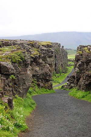 We have rooms for you, said the lady at the reception and here we stop. Most of the budget accomodation in Iceland had shared bathroom facilities. When we reached our rooms, we felt as if we were back in a student's hostel. There were two small cots, side tables with drawers and lamps and a closet to keep clothes, just like we experienced when we were in school. Thats when we realised that the rooms were basically student's accomodation for the school at Laugarvatn and that it functioned as a hotel only for the summer duration (schools remain closed). What a nice way to share facilities!. Now, it was time for dinner and Tor suggested that we go to Lindin restaurant which was mentioned in the Lonely Planet guide. The caption of the restaurant with photographs of duck, reindeer and fish on their web-page (http://www.laugarvatn.is/) says it all - "wild food from Icelandic nature".
  When we reached the restaurant, it was overcrowded and on enquiry, found out that people have to book a seat in advance. But, there was a catch - how can they turn away three smart guys from their restaurant. Within 10 minutes, they were ready with a table for us. Amongst the delicacies on the menu, there was an option of whale meat which my friend had a try. I decided to go for the smoked fish caught fresh from the lake nearby. The food was great and there's no doubt why there were so many people around. On our way back, we had the chance to see a geothermal activity on the lake edge. This was the first time, I am seeing the boiling water of a natural lake and we expected to see more the next day at Geysir. It was now time for a good night's sleep. God Natt!!


No comments:
Post a Comment